High resolution satellite imagery
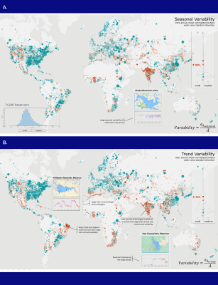
Using high resolution satellite imagery, machine learning, and cloud computing, the study found that the surface area of small reservoirs, which are critical to the well-being of many communities across the world, varies far more than medium-sized reservoirs – 52% more between years and, more importantly, 84% more between seasons.
“Our study provides the most detailed and accurate information on the dynamics of Earth’s reservoirs today. The dataset derived from freely available satellite images of, and open-source algorithms developed in this research will help manage water better, provide early warning for drougths, food shortages, and fact-check local data”, said Gennadii Donchyts, remote sensing expert at Deltares. “Global Water Watch will help to boost transparency on transboundary river water management, across sectors and societal groups leading to higher equality.”
Global Water Watch processes millions of freely-available images from NASA/USGS Landsat and ESA/Copernicus Sentinel satellite missions to generate information on water availability for thousands of reservoirs globally and makes this information freely available to anyone to ensure sustainable water use.

Managing water resources sustainably, efficiently and equitably
While most previous studies have focused on large reservoirs and lakes, this paper shows how Global Water Watch datasets and algorithms can provide unprecedented information to support water managers and river basin authorities as well as communities and companies to regularly monitor water dynamics in small and medium reservoirs – helping them to manage water resources more sustainably, efficiently, and equitably.
“The growing ability to leverage high-resolution satellite imagery to monitor emergent water risks is changing how we can support communities and basins in the face of climate instability,” noted Alexis Morgan, WWF’s Global Water Stewardship Lead. “At WWF, we see Global Water Watch as a key resource for the water community that can increase water data transparency and help democratize information.”
“Growing pressures on water resources undermine water security and contribute to conflict, migration, health crises and food and energy insecurity across the world,” said Charlie Iceland, Interim Director, Water Program, World Resources Institute and a lead of the Water, Peace, and Security Partnership. “Data on global water resources is essential for managing these risks and challenges.”
“At Google.org we believe that advanced technologies like Global Water Watch are changing the game in helping us understand, monitor, and predict water resource availability around the world. Global Water Watch is the type of climate solution that is only possible through the application of AI with Earth observation data.” said Andrew Dunckelman, Head of Impact and Insights at Google.org. “We’re incredibly proud to support this vital work and help Global Water Watch become the go-to platform for discovering and accessing water data in support of adaptation efforts for our changing climate.”
Better response to extreme weather events
The Global Water Watch platform provides critical information that will help decision-makers respond to extreme weather events, manage growing risks of climate change, make societies more climate resilient and preserve and restore our vital ecosystems and the many services they provide. With increasing global warming, droughts such as currently happening in Europe, will happen more often, which together with growing water demands will severely affect the freshwater availability for food and drinking water. Transboundary and basin-wide monitoring of these scarce resources then becomes ever more important to better manage the little resources available.
Read the article
Access the full article here.
To cite this article
Donchyts, G., Winsemius, H., Baart, F. et al. High-resolution surface water dynamics in Earth’s small and medium-sized reservoirs. Sci Rep 12, 13776 (2022). https://doi.org/10.1038/s41598-022-17074-6
This post has been originally published on the Deltares website.
Deltares uses our high-quality knowledge and resources to serve technological breakthroughs in the field of water and the subsurface. We do that in collaboration with the (business) community and other (research) institutes for the benefit of people, the environment and society. By enabling others to have a meaningful contribution to a shared solution, ownership and social learning are promoted.
0 Praat mee